
The mountainous region of India, point-wise, is explained through a map. Only important material for the competitive exam has been included.
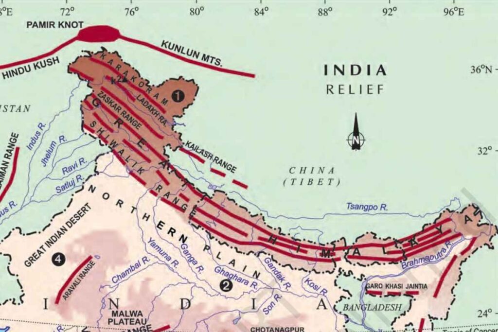
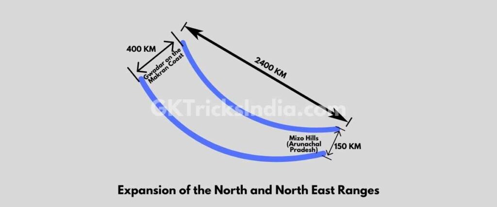
- The northern boundary of India is the wide Himalayas, a geologically young and structurally folded mountain range.
- These mountain ranges extend from the Indus to the Brahmaputra in the west-east direction.
- It spread over an area of 5 lakh square kilometers, are 2400 km long and form a semicircle, its width is 400 km in Kashmir and 150 km in Arunachal Pradesh.
This area is divided into the following parts:
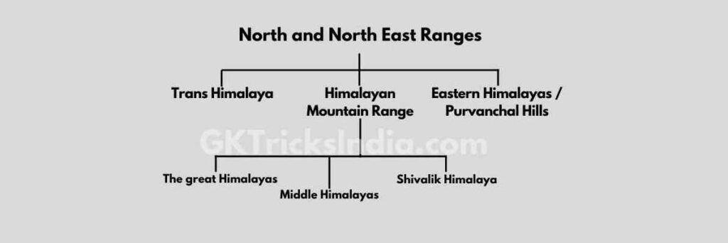
Trans/Tibet Himalaya
- Located in the north.
- Karakoram, Ladakh, Zaskar, Kailash mountain ranges are located.
- The Karakoram range is called the Backbone of High Asia.
- The Indus river cuts across the Ladakh range to form the Bunzi Gorge.
- Godwin Austin (K2), India’s highest peak, is in the Karakoram range.
- Important Glaciers – Valtero and Viapho (in Shigar Valley), Siachen (in Nubra Valley).
- Origin of rivers- Brahmaputra, Indus, Sutlej.
- Due to the cold tropical climate, there is a complete lack of vegetation on it.
Himalayan Mountain range
- It is one of the world’s new folded mountains, which is mainly made up of layered rocks.
- It was built in the Tertiary period.
- This mountain extends from Nanga Parbat (Jammu) in the west to Namcha Barwa (Arunachal Pradesh) in the east. [Mountainous Region of India]
- Since the Carboniferous period, Peninsular India has been moving north and northeast continuously, resulting in the collision of the Indian-Australian Plate with the Eurasian Plate, which is moving south at a relatively slow rate.
- The collision of these two plates put pressure on the deposits of the Tethys Sea located between them, which resulted in the origin of the Himalayas.
- Since the Indian-Australian plate is still in motion, this is the reason why the uplift of the Himalayas continues even at the present time.
- The Himalayas are tectonic (folded) mountains.
- The rise of the Himalayas was completed in three phases, resulting in the formation of three clear ranges, where the Himalayas are presently there, about 7 crore years ago, the Great Himalaya was formed in the Oligocene period, located in the form of the Tethys Sea and parallel to the Himalayas in the south. A trough was also formed which was later filled by the deposits brought by the Himalayan rivers. Thus, due to the earth movement of the Miocene period, the middle Himalayas were formed in the second phase. The last rise of the Himalayas took place in the Pliocene period. The rise of this third phase resulted in the formation of the Shivalik Himalayas.
- Thus the Himalayas is a tectonic (folded) mountain, its uplift has been completed in 3 phases, resulting in the formation of three clear ranges:
- The great Himalayas
- Middle Himalayas
- Shivalik Himalaya
Greater Himalayas (Interior / Himadri)
- It is the most prominent and highest range of the Himalayan ranges.
- The core of this part of the Himalayas is made of granite.
- Due to the high altitude, the Himalayas remain covered with snow throughout the year, hence it is also called Himadri.
- The main glaciers in this Himadri are Milan, Gangotri, and Jemu.
- Its average altitude is 6000 meters. [Mountainous Region of India]
- The world’s highest peak Everest Nepal is in this mountain range, some important peaks are Kangchenjunga, Nanga Parbat, Kamet, and Namcha Barwa.
| Zojila Pass | Situated in the Zaskar range of Jammu and Kashmir, it connects the Kashmir Valley with Ladakh i.e. Leh and Srinagar. |
| Lipulekh pass | It is located in the state of Uttarakhand. [Mountainous Region of India] |
| Boom la pass | Located in western Arunachal Pradesh. It connects China with Arunachal Pradesh. It is a pass in the great Himalayas. |
| Diphu Pass | Located in central Arunachal Pradesh, this pass connects China with Arunachal Pradesh. |
| Mana Pass | Situated in the great Himalayas in the state of Uttarakhand. |
| Neeti Pass | Located in the state of Uttarakhand. Kailash Mansarovar Yatra is done through this pass. |
| Jellepla Pass | Situated in the state of Sikkim. At present, the Kalingpong to Lhasa road passes through it. |
| Nathula Pass | Situated in the state of Sikkim. It connects Darjeeling, Chumbi Valley, and Tibet. |
| Burzil pass | It is located in the Great Himalayas that connects Pakistan Occupied Kashmir and the Kashmir Valley. It is formed by the river. |
| Shipki La Pass | It is a pass formed by the Sutlej River in the Great Himalayas that connects Himachal Pradesh with Tibet. [Mountainous Region of India] |
| Bara-lacha | It is situated in the great Himalayas. This is a major pass connecting Himachal Pradesh and Kashmir. |
Major peaks of the Greater Himalayas
| Peaks | Height (in Meter) |
| Everest | 8,848 |
| Kangchenjunga | 8,598 |
| Makalu | 8,481 |
| Dhaulagiri | 8,172 |
| Nanga Parbat | 8,126 |
| Nanda Devi | 7,817 |
| Namcha Barwa | 7,756 |
Middle Himalaya or Lesser Himalaya (Himachal)
- It is the most uneven and was formed mainly from highly compressed modified rocks.
- Average altitude 3700 to 4500 m. [Mountainous Region of India]
- The longest and most important of the Pir Panjal series.
- Valley of Kashmir Kangra and Kullu Valley of Himachal – This region is known for hill towns.
- Major Ranges: Pir Panjal, Dhauladhar, Mussoorie, Nagtiba, Madhya Bharat Ranges.
- There are alpine pastures called Marg (Gulmarg, Sonmarg) in the Kashmir Valley and Bugyal or Payar in Uttarakhand.
| Banihal Pass | It is located in the Pir Panjal range in the southwest of the state of Jammu and Kashmir. The route from Jammu to Srinagar passes through this pass. It is also called the Gateway of Kashmir Valley. India’s longest tunnel – Jawahar Tunnel is built on it. |
| Pir Panjal Pass | It is located in the southwest of the state of Jammu and Kashmir. It is a major pass located in the central Himalayas through which the medieval Mughal road passes. |
| Baramulla Pass | It is located on the Line of Control (LoC) of Pakistan Occupied Kashmir and is a pass formed by the Jhelum River. It currently separates Kashmir from Pakistan. |
| Rohtang Pass | The pass is located in the Dhauladhar range in the Himalayan region. It is very popular among tourists. |
Major Ranges of Central Himalayas
| Pir Panjal Range | in Kashmir |
| Dhauladhar Range | in Himachal Pradesh |
| Mahabharat Range | in Nepal |
| Mussoorie Range | in Kumaon |
| Nag Tibba | In Uttarakhand |
Shivalik Himalaya (External)
- The outermost range of the Himalayas The newest part of the Himalayas.
- The average altitude is 900 – 1100 meters.
- The ancient Indo-Brahma river used to flow where Shivalik is today. The Shivalik Himalayas originated from the melting of sediments deposited in the valley of this river.
- Between the Shivaliks and the Lesser Himalayas, there are many subsidies such as the Kathmandu Valley. In the West, they are called Doons.
- Famous doons are- Dehradun, Kotli Doon, and Patlidoon.
Eastern Himalayas (Purvanchal Hills)
- This mountain range extends from north to south on the border of India and Burma (Myanmar). It includes Mishmi and Patkai Boom (hills), Naga hills, Tripura hills, Cachar hills, Mizo hills, Manipur hills, etc. These hill ranges also formed during the formation of the Himalayas.
- Saramati is the highest peak of the Naga Hills. [Mountainous Region of India]
- The highest peak of Mizo Hill is the Blue Mountains. Uttar Bharat Ka Parvatiya Kshetra
- The hills of Purvanchal provide direction to the Indian monsoon.
- These hills act as a water divider as well as a climate divider.
Territorial classification of Himalayas
In addition to this north-south, the Himalayas are also divided on the basis of regions located from west to east. These classifications have been done on the basis of the boundaries of river basins.
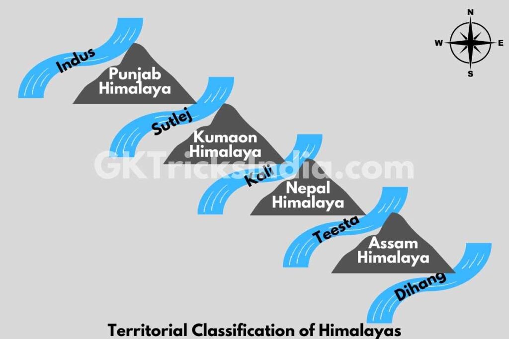
The regional classification of the Himalayas has been done on the basis of rivers. This regional classification is also called the regional classification of the Himalayas.
Punjab Himalayas
It is situated between the Indus and the Sutlej River. Kashmir and Himachal Pradesh are located in this part. The maximum width of the Himalayas is found in this part. Its length is about 560 kilometers.
The Karakoram, Ladakh, Zaskar, Pir Panjal and Dhauladhar ranges lie in this part.
Kumaun Himalaya
The extent of Kumaon Himalaya is 320 km. It is situated between the Sutlej River and the Kali River. The Ganges and Yamuna rivers originate from the Kumaon Himalayas.
The peaks of Kamet, Nanda Devi, Gangotri, Mana, Trishul, Kedarnath, Badrinath, etc. are located in this part. Mussoorie range and Nag Tiba are also part of the Kumaon Himalayan range.
Nepal Himalaya
The maximum length of this Himalaya is about 800 km.
The extension of this Himalaya is from Kali River to Teesta River.
Mount Everest, Kangchenjunga, and Makalu peaks are in this range. The highest part of the Himalayas, Nepal is located in the Himalayas.
Assam Himalayas
The Assam Himalaya is spread over a length of 720 km between the Teesta River to the Brahmaputra River. This Himalayan range is lower than the Nepal Himalayas and is located in the states of Sikkim, Assam and Arunachal Pradesh, and Bhutan. The major peaks of the Assam Himalayas are Namcha Barwa, Sendapu Gyala Peri, Kangto Sanglung and Tiba Kangri.
Questions and Answers
How many mountain regions are there in India?
Seven significant mountain ranges in India have peaks higher than 1,000 meters. The Himalayan range is the most well-known and tallest mountain range in India. Additionally, it is the newest and longest mountain range in India, and it contains practically all of the world’s highest peaks.
Which is the largest mountain in India?
Kangchenjunga
Kangchenjunga, often known as the Five Treasures of Snow, is a majestic mountain that rises 8586 meters above sea level. A mountain besides the Tamur River separates India from Nepal. It is the third-highest mountain in the world and the highest peak in India.
Which states fall in the mountainous region of India?
There are 13 Indian States/Union Territories that make up the 2500 km long Indian Himalayan Region, including Jammu and Kashmir, Ladakh, Uttarakhand, Himachal Pradesh, Arunachal Pradesh, Manipur, Meghalaya, Mizoram, Nagaland, Sikkim, Tripura, Assam, and West Bengal.
Which 4 mountain ranges are located in India?
The Greater Himalaya Range, the Middle Himalaya Range, the Outer Himalaya Range, the Karakoram Range, the Western Ghats, the Eastern Ghats, and the Aravalli Range are the seven main mountain ranges in India.
What are the major mountain ranges of India?
The Great Himalaya, Middle Himalaya, and Outer Himalaya mountain ranges are physically separated into India. The Great Himalaya is the highest region, with peaks that are always covered with snow and reach elevations of more than 22,000 feet.
What are the 3 ranges of Himalayas?
1. The Great Himalaya, or Himadri, is the farthest to the north. This range contains the tallest peaks on the entire planet.
2. South of Himadri is the Middle Himalaya, often known as Himachal.
3. The furthest southerly range is the Shiwalik.
Friends, if you find any kind of mistake or error in this article then please comment or mail us, so that we can rectify these mistakes.